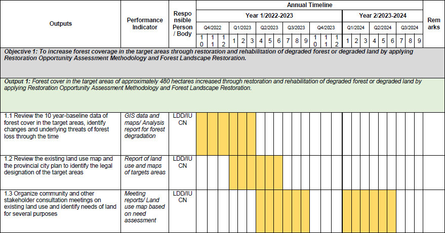
.png)
Pa Leaw Luang Sub-district,
Santisook District, Nan province is a home to 4,485 people living in 10
communities in the overall sub-district areas of
around 10,500 hectares including residential areas in the political boundary
and natural forests inside and beyond the borders. Most
of the people living in this area is hilltribe people (Lue
ethnic group). 85% of
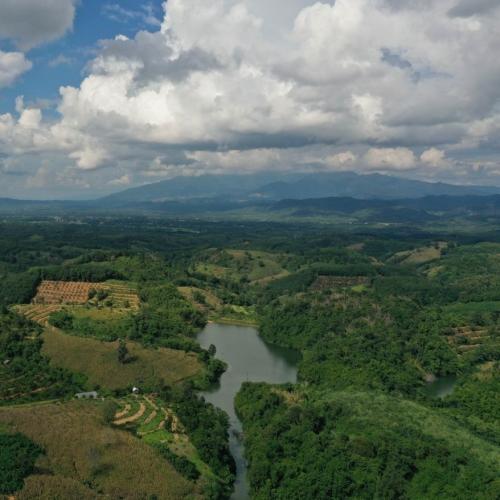
the landscape is high and steep mountain, which is about 600-1,200-meter
above the sea level. In the past 15 years, lowland areas
nearby the steep mountain have been converted to monoculture plantation for
maize and rubber trees and encroach further to higher
mountain areas. Land use conversion causes landslides,
flash flood and drought, which cause economic and livelihood loss severely in
each year. Ongoing deforestation in this area causes soil erosion,
unhealthy land, loss of biodiversity and malfunction of ecosystem services,
which eventually affect the livelihood security of local community members.
Landless local people
in Pa Leaw Luang sub-district illegally used some parts of the Tham
Sakern National Park areas for agricultural plantation. Most
of local people in this sub-district do not have
any legal land titles, therefore their illegal agricultural lands were taken
back regarding to the re-claim land policy
endorsed by the government in 2014. Many of them are
still in conflict with the government agencies and the land occupancy is not
yet resolved in this area. Several organizations have initiated many projects to stop forest
encroachment for agricultural land and introduced different livelihood
initiatives, however many of those projects have not comprehensively addressed land needs and livelihood diversification to stop deforestation. In 2019, Pa Leaw Luang model has been developed in responding to the
master plan of “Nan Model”,
which was initiated in 2009, to solve deforestation problem. Pa Leaw Luang model composes
of the forest restoration and livelihood development activities
initiated by Community Organization Development Institute and Royal Forestry
Department, Ministry of Natural Resources and Environment. There
are opportunities to collaborate with all related stakeholders through this
ongoing project (Pa Leaw Luang Model) to
improve forest recovery, including livelihood options for local people. It
is important to have a long-term strategic forest
restoration, monitoring and evaluation for forest recovery collectively
designed at the sub-district level in collaboration with all
related stakeholders. There is a need to improve people’s
livelihoods, empowering people to diversify sources of incomes from sustainable
practices of agriculture, as well as raising awareness on sustainable land and
forest management for better land and forest productivity and livelihood
improvement.
The project aims to restore healthy and productive landscapes through
improvement of livelihood and forest restoration as the key elements for improved sustainable land and forest management. The
project will develop Sustainable Land Management (SLM) interventions
addressing land and ecosystem restoration within identified demonstration sites
considered as ‘hotspots’ or
mostly affected by land degradation, loss of biodiversity and impacts of
climate change in the target areas. The SLM interventions
entails capacity building, scaling up and mainstreaming climate smart and
innovative SLM practices/ forest management
practices and technologies that will be identified by farmers and land users at
the landscape areas. The project will increase awareness of
stakeholders and facilitate engagement of local farmers, land users at the
landscape levels to improve understanding of land degradation, sustainable
forest management and impacts of climate change in the target areas, changes in
biodiversity, productivity, effective provision of ecosystem services and
sustainable land management practices that can be scaled up.
The project responds to the implementation of LDN’s targets at local level, Thailand’s international commitments to the Climate Change Treaty and the Conventions on Biodiversity and Combatting Desertification (CCD). The project will develop a pilot model of sustainable land management and integrated forest management at the local level, which focuses on implementation of measures in responding to the targets of National Land Degradation Neutrality (LDN), and address the raising concerns of greenhouse gas emission from agricultural and forestry sectors. Eventually, the project results will contribute to the achievement of already negotiated national targets of the Land Degradation Neutrality (LDN) and Nationally Determined Contributions (NDCs) and Biodiversity Convention, when the model is replicated in other prioritized degraded areas in Thailand.
Vast array of agricultural lands in Thailand are in varying states of
degradation. Of the 29.12 million ha of
agricultural land, the Land Development Department estimates that 56.8% of
the country’s terrestrial areas is classified as ‘degraded’ (LDD
strategy 2017-2021, Sep 2016). The
northern region is particularly at risk from land degradation, each with their
own combination of drivers. Soil erosion is a
widespread environmental challenge across Thailand, with 21.52 million
ha of agricultural land considered as ‘highly vulnerable’ to
soil erosion impacts in the absence of adequate soil conservation measures (LDD
strategy 2017-2021, Sep 2016). This
is a particular challenge in the northern region of Thailand, with its steeper
slopes and high rainfall. Soil
degradation also is defined as a change in the soil health status
resulting in a diminished capacity of the ecosystem to provide goods and
services for its beneficiaries. Agroforestry or
integrated forest management are an integrated approach using of trees in
farming systems to the deliberate growth and management of trees along with
agricultural crops and/or livestock in systems that are
ecologically, socially and economically sustainable. Both
farmers and scientists should test and validate the aims, potential and
positive interactions among both socioeconomic and ecological components. Some
important aims of agroforestry are increased productivity/income
and improved equity in benefit-sharing sustainable
land management.
Impacts of climate change and disaster risks in Thailand are reportedly
more frequent and extreme, affecting the sustainability of agricultural,
forestry and food production. This requires a focus
on developing sustainable agricultural systems through, for example,
agriculture diversification, and nutrition-sensitive
agriculture, Climate Smart Agriculture such as soil conservation, integrated cropping and agroforestry, and
Good Agricultural Practices. In order to maintain the genetic diversity of
seeds, cultivated plants, farmed and domesticated animals and their related
wildlife species, the gene, sperm and seed banks should be established at the
national and local levels.
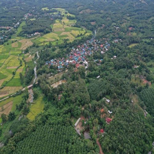
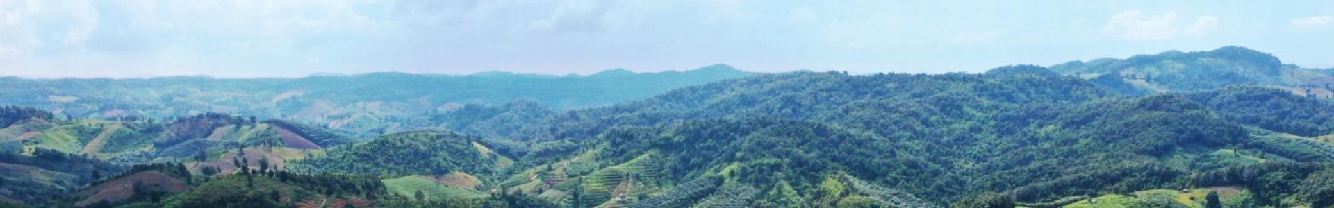
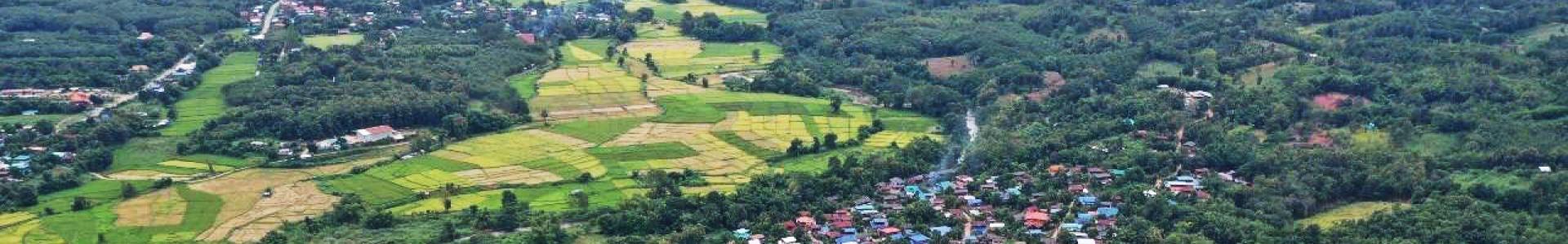
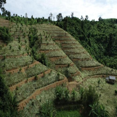
Pa Leaw Luang Sub-district locates in
Santisook District, Nan province in the areas of 10,500 hectares in the
political boundary of the sub-district. It
consists of ten communities, which home to 4,485 people.
Majority of local people here is Tai-Lue ethnic group. 85% of
the landscape is the highland, 600-1200 meters above the
sea level, especially on the East and West of the sub-district. There
are two tributaries, Muab and Yang River run through the central plain of the
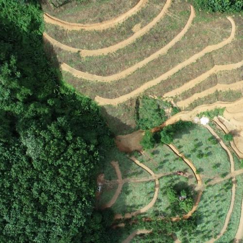
sub-district. Agricultural
activities are the major drives of land use conversion
mainly
at the slope areas. 6,954 hectares of forests were removed
drastically and converted to agricultural plantation in Pa Leaw Luang Sub-district. Maize and rubber plantation were
promoted by the Thai government agencies and fully implemented by local farmers
during 1997-2012. Agricultural area had
been extended to the preserved forests and the protected areas, which caused
the massive disasters in this area; for example, flash flood and land slide
during the monsoon season. Soil quality has been
degraded due to heavy use of chemical fertilizer; pesticide and herbicide, as
well as the long-term monoculture in the areas. Alluvium
transportation and landslide caused shallow rivers and affects socioeconomic
activities of locals already. Meanwhile, local
people experience drought and water scarcity in dry season for their daily
consumption and agricultural plantation.
Pa Leaw Luang Sub-district was one of
the strategic areas of the Communist movement in Thailand. In
the past, there was no forest plantation along the street in Santisook district
in the deep distance of 1.5 kilometers from the
main street. After the political unrest was settled, the Thai
government started the socioeconomic and agriculture for livelihood development
in this area. In 2002, The Thai government promoted
maize and rubber plantation. Forests had been
drastically removed for monoculture plantation. The
agricultural land encroachment consistently expanded and resulted in land
degradation due to the use of chemical fertilizer and pesticide. It caused the loss of watershed areas, drought, flash
flood and landslides. In addition, Nan Model was initiated
in 2009 by the Community Organization Development Institute and Pid Thong Lang
Pra Foundation, which aims to use this model as a master plan to improve
livelihood of local people especially agricultural practices. Until
2014, the Thai government started to implement the re-claim
forest policy all over the country and Santisook district has been prioritized
as one of the restoration models. Pa Leaw Luang Model
is being developed by Royal Forestry Department in responding to the forest
restoration and land reform policy.
Royal Forestry Department (RFD) developed
and implements the restoration plan for Santisook district as a part of the
umbrella project of “Nan Model”,
which has jointly designed and invested by different stakeholders. There
are several non-profit organizations, research institutions,
private sectors, local authorities and the government
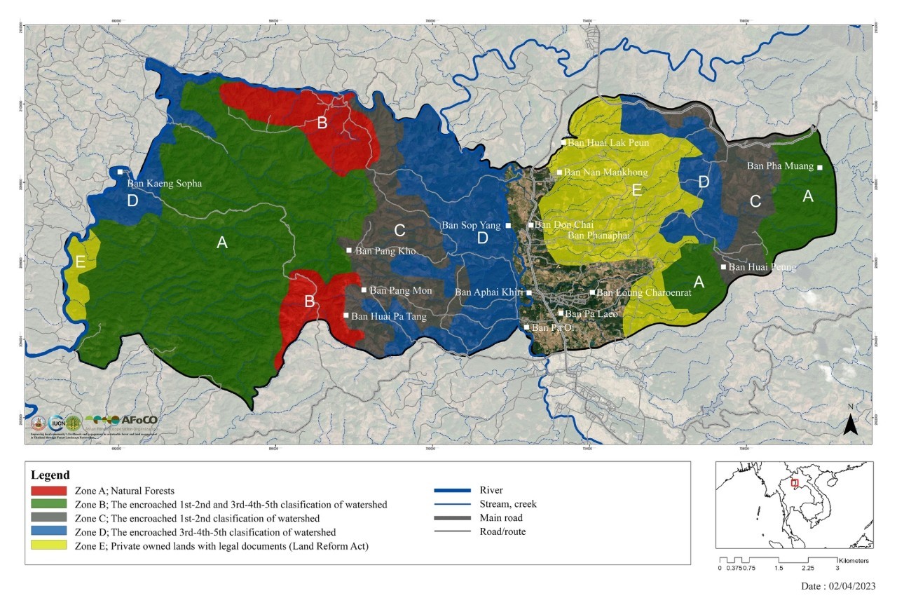
agencies invested in forest replantation in the past ten years. Pa Leaw Luang Model consists of land zonation and strategic
plan to restore each zone designed by RFD. The designated zones
consist of 1) natural forests, 2) re-claimed
forestlands, 3) the encroached 1st and 2nd
classification of watershed, and 4) the encroached 3rd,
4th and 5th classification of watershed. However,
the degraded areas are very large and require consistent efforts and investment
in a long term from all related holders based on the strategic restoration plan. The
comprehensive monitoring plan for the restored areas is needed. Local
people engaged in the replantation activities by planting and preparing the
areas only. There is a need to apply the participatory process of
Forest Landscape Restoration (FLR),
the Restoration Opportunities Assessment Methodology (ROAM),
and participatory monitoring and evaluation plan in
the restored areas in this sub-district. In
addition, capacity building approaches for socioeconomic livelihood
alternatives based on their biodiversity capitals and forest restoration
methodologies to these communities are needed as well.
The Thai government realizes and prioritizes land need issues of
landless farmers. The National Land Reform policy and
the National Land Policy Committee are established by the Thai government to
manage the degraded lands and local people who are in needs of the lands. Land
zonation, community land deeds, integrated agriculture promotion, community
development plan, and water resource development for agriculture are the key
elements of this forest and land restoration model. The
Royal Forestry Department has zone designation based on the location of the
forests, ecological function and utilization of local people in a long run. Forest
restoration in the watershed areas, establishment of forest restoration center,
conservation and protection to the natural intact forest, establish of
community forest, land right allocation for landless people after the land has
been restored, economic forest, community nursery and CCTV installation and
connection through the satellite for monitoring the forest recovery. However,
there is a need to review the plan and identify the success, challenges and
gaps in restoring the forests in this target area as planned, as well as
increasing level of people engagement in monitoring and evaluation of the
restoration activities led by the Thai government agencies. Scientific knowledge on monitoring flora and fauna
species recovery in the target restored areas will be introduced to local
people with simplified tools and methodologies for them to monitor the target
areas. It is important to ensure that long term strategic
restoration plan developed for this area will support local community’s
socioeconomic needs and other adaptive land use requirements in the future.
According to livelihood improvement on agricultural
related activities and other alternatives, although there are several projects
led and supported by the government agencies and NGOs, the improvement of the
supply chain, production plan, market plans, technical knowledge improvement of
the farmers, adaptation and mitigation plan in responding to impacts of climate
change are required for those farmers in the target areas. The
agricultural practices, at the present, are heavily depending on monoculture (maize and rubber plantation) and
conventional methods of farming by applying chemical fertilizer, slash and burn
to clear the land. The negative consequences of these
unsustainable practices will potentially lead to forest encroachment for
seeking more fertile lands. Therefore, introducing options
for more environmentally friendly agricultural practices with practical market
strategic plans to promote their products, diversification of non-agriculture
related livelihoods is needed to lessen the pressures on land use for
agriculture and forests, as well as ensuring alternative sources of income for
local communities.
In addition, the AFoCO project (AFoCO/009/2015) titled “Developing High
Valuable Species in Viet Nam & Thailand as a Mechanism for Sustainable
Forest Management & Livelihood Improvement for Local Communities”,
which was implemented in Nan and Loei province in 2016-2019
could be replicated and scaled up in Pa Leaw Luang sub-district,
Nan province as well. The most applicable approach of this
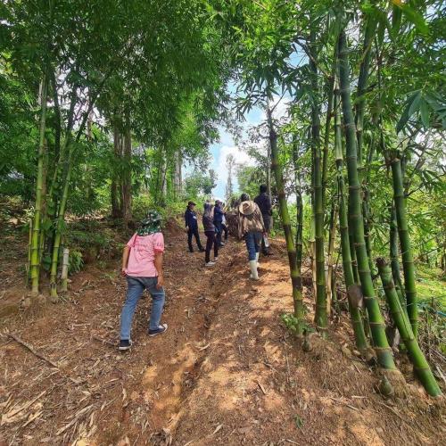
project is the use of high value species; Bamboo as a pilot species to develop
market strategic plans, capacity building program for local people in bamboo
farming and having bamboo processing products, along with sustainable forest
management and agroforestry in the target areas. Royal
Forestry Department as the implementing agency of the project and Land
Development Department will be able to share lessons learned and transfer
knowledge from this successful project to the newly proposed
one in 2021. Bamboo, high value hard timber and rice will be one of
the agricultural species that Royal Forestry Department, Land Development
Department and other implementing partners in the target areas could jointly
promote among the local communities.